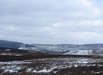
 Bilsdale is the valley of the River Seph, and one of the longest dales in the Moors, running from the north-western edge of the moors between Hasty Bank and Urra Moor to its junction with the River Rye about a miles east of Hawnby.
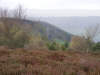 Bilsdale is big enough to have side-dales of its own. Raisdale cuts into the moors to the west of the valley, running through a rare area of individual hills. Further south is Tripsdale, which cuts into the high moorland to the east of Bilsdale, running south from Round Hill, the highest point on the Moors.
The valley was probably at least partly created by melt water from glaciers, running south from a massive lake formed in Esk Dale.
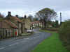 As is so often the case the valley contains no villages, but there are hamlets - Urra on a side road near the northern end of the dale, Seave Green and Chop Gate near the junction with Raisdale and Fangdale Beck further south along the valley. The majority of inhabitants of the valley live in the many scattered farms. Chop Gate (pronounced Chop Yat) is the site of the Bilsdale Show (http://www.bilsdaleshow.co.uk/content/home-page)
Bilsdale has its fair share of historic features. The most impressive is the long earthwork that runs along the top of the eastern slopes, starting at the northern end of the valley (where the Cleveland Way reaches the top of a steep climb), and runs south alongside Urra Moor for several miles, ending east of Chop Gate. The bordering ridges have their fair share of tumuli and other earthworks.
 More recent is the Spout House, a sixteenth century cruck-framed house that used to be the Sun Inn (from 1714 to 1914). It was restored by the National Park and is now open to the public. Just outside the pub is the tombstone of Bobby Dowson, whipper in for Bilsdale Hunt in the 19th century. According to local legend the vicar refused to allow the stone to be erected in the churchyard because it referred to Dowson's hunting exploits. The Sun Inn has now relocated next door.
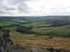
Bilsdale is familiar to many, as it contains the B 1257 Stokesley to Helmsley road, a popular route across the Moors. The road drops down into the valley on Newgate Bank, almost at its southern end, and runs the full length of the valley from there, crossing the northern escapement at Clay Bank.
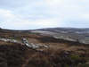 There are several car parks along the valley. The first is at the top of Newgate Bank, and offers some great views up the valley. The second is just to the south of Chop Gate, and is the only one in the valley bottom. Finally there is an excellent car park at Clay Bank, technically just outside the valley, but within a short distance of the very top of Bilsdale.
The meaning of the valley name is unclear. One early reference calls it Dildes Dale, which may refer to the rocky outcroppings at the northern end of the valley, a rare site in the Moors. Sadly this means that one local legend can be discounted. According to this tale William the Conqueror got lost in the fog while travelling through the valley, and his language was so bad that it gave rise to the saying to 'swear like Billy-O'. The valley thus took his name, as 'Bill's Dale'.
Go to Bilsdale Photo Gallery
Walks
NZ 5703/01 Clay Bank to Cringle Moor
NZ 5703/02 Clay Bank to Round Hill
SE 4597/01: Osmotherley to Beacon Hill
SE 5489/03 Easterside Hill
SE 5599/01: Cold Moor
SE 5599/03 Nab End and Round Hill
SE 5689/01 Rievaulx and Helmsley Moors