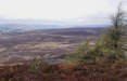
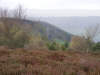
 This simple walk is notable for the impressive views north towards the highest parts of the Moors and the Cleveland Hills, and south towards the Yorkshire Wolds. Although we retrace our steps from the highest point above Helmsley Bank, our attention is drawn by the wild expanses of the high moors on the way out, while on the way back we face Easterside Hill and then the Wolds.
Ascent: 280ft/ 65m
Length: 4 miles/ 6.5km
Map: Ordnance Survey Explorer Map OL26
Last Walked: 28 April 2008
Go to printable version
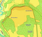
We start from the excellent car park at the top of Newgate Bank, on the B 1257 at the southern edge of Bilsdale.
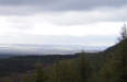
After about a quarter of a mile our path reaches a fenced-off area of young trees. After a short distance running alongside the fence, the path turns right, and joins a track that runs around the edge of Rievaulx Moor. Turn left onto this track, and follow it all the way to the trig point above Helmsley Bank, at what is clearly the highest point on this moor.