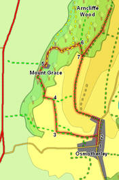
 This walk is unusual in that it requires access to Mount Grace Priory, a National Trust property, so it is best suited to NT members or someone who is planning to visit the priory anyway. If the Priory is not open the only way around it is an awkward scramble through the overgrown woods behind, not to be recommended. (see the National Trust website for opening times).
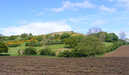
After visiting the priory we continue on into Mount Grace Woods, and then climb up onto Beacon Hill before returning to the village.
Ascent: 800ft
Length: 4.2 miles
Map: Ordnance Survey Explorer Map OL26
Last Walked:
Go to printable version
We start from the centre of Osmotherley
 After running straight west for some way Cuddy Lane turns sharply to the right, running along the left-hand side of a hedge, while a footpath runs north along the right-hand side of the hedge. Take this footpath.
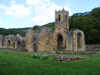 Enter the Priory through the public entrace, in a house built along the western edge of the Priory. Our route used to go through the Forestry Commission land north of the priory, but sadly that has now been sold into private lands and is no longer useable. Instead return to step 4 and follow the path that heads straight up the hillside. This brings us onto our original route back, so skip to step seven.
![]() We are now back on our original route. There is a choice of options - turn right to return to Osmotherley - follow the track as it curves left around Ruebury Hill. This brings us onto the road, where we turn right to return to the village.
We are now back on our original route. There is a choice of options - turn right to return to Osmotherley - follow the track as it curves left around Ruebury Hill. This brings us onto the road, where we turn right to return to the village.
The alternative is to visit Beacon Hill. This is a great viewpoint, looking out south towards the Hambleton Hills and east towards the high moors. To reach Beacon Hill turn left onto the track and head to the edge of the woods. Here there are two footpaths - take the right-hand branch (signposted as the Cleveland Way).This climbs up quite steeply onto the hill top. Follow this path through the woods and onto open ground at the top of the bank.
There is now a second choice to be made. Either walk as far as you want and then turn back to head into Osmotherley on the route described above, or continue past the trig point at the top of the hill, then turn sharply to the right onto the lane that runs south back down Beacon Hill and Swinestye Hill back onto the road north of the village.