 This short walk explores the popular village of Goathland, visits Mallyan Spout, the most famous waterfall in the Moors, explores the dramatic wooded valley of West Beck on its way to the village of Beck Hole, and then returns to Goathland along a quiet back street. Not bad in under three miles!
This walk starts from the main car park in Goathland.
Ascent: 500 feet/ 150 meters
Length: 2.8 miles/ 4.5 km
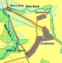
Map: OS Explorer Map OL 27
Last Walked: 19 March 2007
Go to printable version
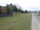 We start at the main car park, on the north side of the main road through Goathland. Cross over the road, and turn right. This is the most touristy section of the village, containing most of the gift shops and tea rooms. At the end of this first section, follow the main road as it turns sharply to the left. One of the most distinctive features of Goathland are the wide grassy verges that line the main road, making the main street feel like a very long thin village green.
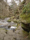
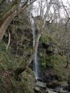 At the bottom of our descent we reach the West Beck. Turn left and follow the path along the side of the stream. This is one of my favourite short sections of path in the moors, running along a rocky shelf by the side of the beck, before reaching Mallyan Spout. This is a charming waterfall in a wooded gorge. The gentle nature of this waterfall can best be appreciated when you realise that the path onwards actually passes under the waterfall.
  Follow the abandoned railway for about 600 feet, until it crosses over the Eller Beck. Immediately after crossing over the beck, turn right and follow the path into Beck Hole.