|
|
Danby is best known as the home of the The Moors Centre, half a mile east of the village. The village itself is spread out along a road running north to south down the side of Danby Low Moor.
The Moors Centre was originally Danby Lodge, a hunting lodge, and is surrounded by thirteen acres of gardens, complete with way marked walks. The centre contains much of interesting, including the obligatory gift shop and tearoom.
 The remains of Danby Castle, one mile south east of the village, have now been turned into a farm house. The castle was probably built between 1396 and 1430 by John Neville, lord Latimer, who inherited the site in 1396. Famous later inhabitants include Catherine Parr, Henry VIII's last wife.
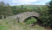
Between the castle and the Moors Centre you will find Duck Bridge, a medieval packhorse bridge, which gains its current name from George Duck, who restored it in the eighteenth century.
Danby can be reached from the A171 (the turn is just over one mile west of Scaling Reservoir), or along the road through Esk Dale.
Public Toilets, Visitor Centre (to east)
Walk NZ7108/01: Little and Great Fryup Dales starts from the visitor centre.
Good paths lead along the River Esk (details of Esk Valley Walks can be found at the visitor centre).
 Danby is on Ordnance Survey Explorer Map OL27 (North Yorks Moors Eastern Area)
Get it from ![]()