|
|
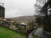
 Thriving village in upper Esk Dale. Castleton is another stop on the Esk Valley Railway (although the village is a one hundred foot climb above the station!). Between the houses you will glimpse views of the surrounding moors, with the Esk seen to the north and Danby Dale to the south.
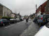
 Castleton offers a good range of shops, as well as a bank and post office. The village stretches out along nearly half a mile of the northern end of Castleton Rigg. As a result, every street in the village is on a slope.
The Church of St Michael and St George is unusually recent, having been built after the First World War as one of the larger war memorials in the country. The benches, alter panels and organ screen were all made by Robert Thompson, the mouse man of Kilburn.
Virtually nothing remains of the castle of Castleton, although the motte is still just visible. Much of the stonework was probably used to build the nearby Danby Castle, constructed by John Neville, Lord Latimer, probably soon after he inherited both sites in 1396.
 Castleton is on Ordnance Survey Explorer Map OL26 (North Yorks Moors Western Area)
Get it from ![]()