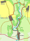
 This walk explores the valley of the River Seven as it cuts through the Tabular Hills, and takes us from the southern edge of the National Park almost to the edge of the open moors. On the way we visit two very different villages - Sinnington, with its large village green, and Appleton-le-Moors, stretched out along a single long street, and use part of the Tabular Hills Regional Trail.
Ascent: 700ft
Length: 7 miles
Map: Ordnance Survey Explorer Map OL26 & Explorer 027 North York Moors East
Last Walked:
We start at the village green in the centre of Sinnington, where parking is available for a contribution to the village funds (honesty box).
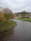 We start on the village green in the centre of Sinnington. Cross the River Seven on the road bridge, then turn right and follow the track that runs along the opposite side of the river. The track runs out of the village and the follows the river as it turns sharply to the left then curves around to the right. As the track runs around the corner, it rises gently above the level of the river, which now runs at the base of a steep slope.
 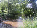 Eventually the river and track separate, with the river curving away to the right and the track continuing on to the north. We follow the track
 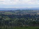 until we reach a footpath that leaves to the right, through a gate signposted as the path to Appleton. This path leads through a short patch of trees, then cuts across the middle of a field (following a very obvious route). At the far side of this first field, turn left and follow the path as it climbs up the hill towards Appleton. We reach the village after about half a mile, and continue on in the same direction, along the single street of Appleton-le-Moors.
 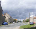 We stay on this road all the way through the village. Just outside the northern end of the village a side-read leaves to the right. Turn right onto this lane and follow it for the next mile and a half. At first it runs east, before turning left to run along a shallow valley. As we reach the northern end of this little valley we are rewarded with views towards the heather moors beyond Lastingham. Finally this land drops down a short slope and curves around to the right, passing around the northern end of Birk Head, before reaching the small hamlet of Lower Askew.
 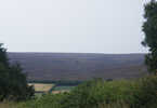 At Lower Askew we reach a junction in the road. Take the right hand branch, and follow it as it crosses the River Seven. On the first side of the Seven the road curves to the right, passes Beckhouse Farm and then comes to a busier road - this is one of the better roads into Rosedale.
 For the next mile this track runs south, with the flat ground around the Seven to the right and Mill Bank to the left. Eventually our track enters Mill Wood, and climbs quite steeply up the northern slope of a spur of the hills. At the top of this mini-ridge our path reaches something of a cross-roads in the trees. Turn right and follow the path that runs downhill along the ridge. At the edge of the trees a gate leads into a small field, while footpath turns left just inside the trees. Ignore the gate, which only leads to a rather overgrown path, and instead turn left and follow the path along the edge of the woods.
We follow this path for about half a mile before it emerges from the trees at the northern tip of a triangular field. Our path heads to the right, passing through a large gap in the hedge, and then runs across the middle of the next field, following an obvious route through the grass.
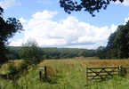 At the far end of this field there is some confusion on the signposts. A clear track heads uphill into the trees, while a footpath is signposted heading to the right. Ignore the footpath sign, which leads to some unpleasant scrambling in the undergrowth, and instead follow the track. We now have a choice of routes - we can follow the track all the way back into Sinnington, or turn off to explore an area of grassland bounded by the River Seven, and lined with a footpath which brings us back to our original track.