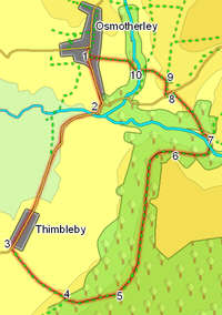
 The woods on Thimbleby Bank dominate the view south from the village of Osmotherley. This walk takes us from Osmotherley to the small village of Thimbleby, then climbs up through those woods, before returning to Osmotherley along the top of the bank.
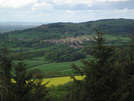
On a good day the views from the top of Thimbleby Bank are extensive - the distant line of the Pennines can sometimes be seen in some detail, while the views towards Osmotherley are some of the best in the area.
Ascent: 920 feet/ 280 m
Length: 4.5 miles/ 7.2 km
Map: OS Explorer Map OL 26
Last Walked: 7 May 2007
Go to printable version
Park in Osmotherley.
 Pass through a gate into the woods. Once in the woods, follow the track that climbs up through the woods - it is signposted as a footpath. After about 200 meters, this track turns left and levels out. At this point leave it and continue to climb up the slope along the signposted footpath. This path follows what appears to be an old track up the hill towards abandoned quarries.
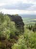
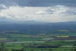 At the top of the bank, our path emerges out into an abandoned quarry. From here there are impressive views west towards the Pennines - on a clear day it is possible to make out the entrance to Wensleydale (see picture, left).
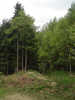
At the far edge of the quarries, the path reaches an impressive hanging stone, perched at the top of the bank. Just beyond this stone, the path turns slightly to the left, and follows a route through the trees at the top of the slope. Follow this path through the woods for the next mile. Along the way the nature of the woods changes repeatedly, ranging from pine plantation to natural broadleaf, with what appear to be escapes from the gardens of Thimbleby Hall mixed in.
At one point our path emerges from the trees to cross a forest track. Ignore the track as it plunges down the slope to the left - instead turn very briefly right onto the track and then almost immediately left back onto a path between the trees.
 For most of our walk through the woods, we are heading almost directly back towards Osmotherley. At the entrance to Oak Dale, the path begins to curve around to the right. Soon after this, it descends down the side of the slope into Oak Dale - follow the signposted path down the slope.