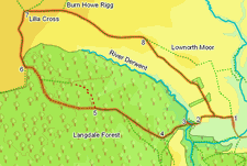
 This walk combines two of the most typical landscapes of the North York Moors. The first part of the walk takes us through Langdale Forest, one of the biggest examples of the modern forestry that cover large parts of the eastern moors. It then emerges from the trees onto the open moors at Lilla Rigg, one of the highest points in the eastern moors. Lilla Cross itself is a superb viewpoint, with views north east towards Robin Hood's Bay and west across the open moors.
Ascent: 900ft/ 280m
Length: 10 miles/ 16km
Map: Explorer 27 North York Moors East
Go to printable version
We start this walk from the road that leads to Lownorth Park. To find this side road from the north, turn right off the A 171 at the northern end of Harwood Dale Forest. Follow this side road for two and a half miles, then turn right twice in quick succession. From the south, the best approach is via Hackness and Silpho.In Hackness take the turn signposted for Silpho. Soon after passing through Silpho, the road reaches the edge of a forest - turn left onto the road here, then turn left again onto a long straight road running through the trees. This road eventually heads down Reasty Hill. Our side road is at the bottom of the bank - take the first left turn.
Once on this side road, follow it to a bridge over Harwood Dale Beck. Drive over the bridge and follow the road as it turns to the right and climbs up the side of a hill. There are several large parking places on the side of this road, which look to be of the same date as the roads inside the park.
Sadly the interesting looking path that is shown on the OS map cutting across the valley of Woof Howe Grain is no longer clear on the ground (the first part, down to the stream is fine, but it disappeared amongst the trees on the other side), so ignore this route and continue along the forest track.
After just under a mile the forest track splits. Follow the right hand branch as it curves around to the north. A short time after passing this junction, we reach High Woof Howe, an ancient earthwork located in a clearing just to the left of the track, which is well worth a visit. From the howe return to the track, and follow it as it curves around to the left to reach the edge of the forest.
This track runs across the open moor towards Brown Hill. Just before reaching this minor summit the path re-enters an area of fields, leaving the open moors behind. It then curves gently to the right as it passes north behind Brown Hill. Just after we pass this hill, a footpath leaves the track and cuts diagonally across the field, heading south east. Our target is a stile just to the right of a small climb of trees at the opposite end of the field.
Follow this path as it runs across a series of fields, each with a patch of woodland at the far end, still heading to the south east. This path runs level across the first three fields before reaching High Seat at the end of the ridge. From here the path heads almost due south, passing between two small plantations and then following the edge of the next field down the end of the ridge. At the end of this field the path cuts across the middle of a smaller field before rejoining the track we used back at the start of the walk. Turn left onto this track. Follow it back to the first farm, and then turn right and return to our starting point.