 This walk has two very distinct phases to it. We start in the wooded valleys of Harwood Dale Beck and then the River Derwent, following the river as it flows though the steep sided Lang Dale.
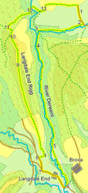
At the southern end of Lang Dale, we then turn back onto Langdale Rigg, a most unusual long, narrow, steep sided ridge which gives us outstanding views over Langdale at the southern end and over Flylingdales Moor and beyond at the northern end.
Ascent: 900ft/ 280m
Length: 8.4 miles/ 13.5km
Map: OS Explorer Map OL 27
Last Walked: 1 April 2007
Go to printable version
We start this walk from the road that leads to Lownorth Park. To find this side road from the north, turn right off the A 171 at the northern end of Harwood Dale Forest. Follow this side road for two and a half miles, then turn right twice in quick succession. From the south, the best approach is via Hackness and Silpho.In Hackness take the turn signposted for Silpho. Soon after passing through Silpho, the road reaches the edge of a forest - turn left onto the road here, then turn left again onto a long straight road running through the trees. This road eventually heads down Reasty Hill. Our side road is at the bottom of the bank - take the first left turn.
Once on this side road, follow it to a bridge over Harwood Dale Beck. Drive over the bridge and follow the road as it turns to the right and climbs up the side of a hill. There are several large parking places on the side of this road, which look to be of the same date as the roads inside the park.
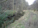 Just before reaching the bridge over Harwood Dale Beck, we reach the entrance to Lownorth Park, currently a biking centre. Turn right into the park, and follow the track as it runs alongside the beck. Keep an eye out for bikes using the same track. The old road through the camp eventually turns into a footpath, which we follow along the side of the beck (see picture).
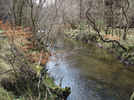 Follow the beck as it curves around to the left, toward the River Derwent. Just before reaching the river, cross over a footbridge that takes us to the southern bank of the beck. Once over the bridge, turn right and follow the path by the side of the River Derwent as it runs through the wooded valley of Lang Dale. This path stays close to the river all the way through the woods, but does have to climb over one or two obstacles. Ignore any path or track that keeps climbing for more than a few feet. The path becomes much clearer after a short distance.
 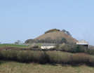 Just outside the hamlet, the road splits. Ignore the left hand branch, which drops back down the hillside, and take the right hand branch, which runs along the side of the hillside, with the isolated outcrop of Howden Hill to our right.
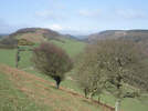
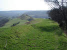 At the end of the first field, there is now a permissive foot path onto the summit of Howden Hill. The view down across Langdale End is well worth the effort. After visiting Howden Hill, return to the saddle, turn right (continuing in the same direction as the path from point 7), then turn left, following the signposted footpath that leads up onto the clearly visible ridge. This path follows the ridge line up onto an open grassy pasture, and then into part of Langdale Forest.
 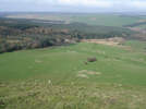 The northern end of the Rigg is clear of trees. After emerging from the trees, we cross an open field with trees to the left. A path is marked as running down the northern slope of the Rigg, but the start of that path is not visible on the ground, and it leaved across private ground. Just short of the trig point, the right of way turns slightly to the left, and follows a forest track down the western slope of the rigg. You may wish to visit the trig point to admire the views, but after doing so return to this track to continue.
 We now have to get back across the River Derwent. Here there is a small problem - the forest track reaches a ford, which might be too deep to cross easily. There is a footbridge further right along the river, but the path marked as going to this bridge doesn't seem to exist (see above). Instead follow the track down to the river bank. If the ford is usable, cross over it, and follow the track as it climbs up from the river. There is also a second, slightly more shallow ford a little to the left, but beware of very wet ground just off the road.
If you need to use the bridge, turn right, but not along the river bank - there is no way through at water level. Instead, climb back slightly up the hillside, and make your way through the trees above the river. There is a rough path through the trees, at the top of a steep bank (almost a cliff in places), which soon drops back down to the side of the river, close to the footbridge. Cross over the bridge, and climb straight up the side of the hill to the track.