|
|
 This walk takes you from the southern edge of the moors, along one of the steep sided valleys that cut through the Tabular hills and to the edge of the high moors, before returning via Gillamoor and the top of the tabular hills, with views south towards the Howardian Hills.
Ascent: 1222 feet/ 372 meters
Length: 11.5 miles/ 18.6 km
Map: OS Explorer Map OL 26
Last Walked: 1st April 2006
Go to printable
Through the trees to your left, you will catch a glimpse of Kirkdale Church, one of a very small number of Anglo-Saxon churches still to survive. If you want to visit the church, cross over Kirk Beck, then take the first path right. Once you've finished at the church, retrace your steps.
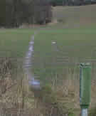
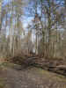 The track you are following soon turns right, and leads up Kirkdale Howl. Ignore this track, and another path that heads up the slope (see photo left). Follow the third path, running along the bottom of the valley, just inside the woods.
 Soon after passing the weir, the path closes up with the beck for a short patch, before another field opens up between the woods and the water. Keep to the track along the edge of the woods until a path heads off into the trees. Follow this path, which runs parallel to the edge of the woods, just inside the trees, for the next two thirds of a mile.
Ignore any tracks or paths leading uphill into the woods.
Soon after passing the weir, the path closes up with the beck for a short patch, before another field opens up between the woods and the water. Keep to the track along the edge of the woods until a path heads off into the trees. Follow this path, which runs parallel to the edge of the woods, just inside the trees, for the next two thirds of a mile.
Ignore any tracks or paths leading uphill into the woods.
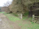
 has access to this field. If the bull is in the field, or you don't want to take the chance, then keep to the path in the woods, which will rejoin the main track at the other side of the field.
This track climbs slowly along the side of the valley. To the left you can see Hodge Beck as it meanders across the valley floor. Beyond that, you will catch your first glimpse of the high moors on this walk.
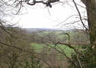
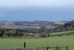 We now join another tarmaced road, heading through the woods towards Stonely Woods (to our left). Keep straight ahead on this road, following it as it turns to the right. Ahead of us is this walk's 'surprise view'. From our viewpoint we can see for miles along the escarpment that marks the northern edge of the Tabular Hills, before the line of the hills turns out of sight just beyond Cropton Bank, five miles to our east.
This is probably the best viewpoint on the walk (Gillamoor's own 'surprise view' comes close, and we are about to head there).
We now join another tarmaced road, heading through the woods towards Stonely Woods (to our left). Keep straight ahead on this road, following it as it turns to the right. Ahead of us is this walk's 'surprise view'. From our viewpoint we can see for miles along the escarpment that marks the northern edge of the Tabular Hills, before the line of the hills turns out of sight just beyond Cropton Bank, five miles to our east.
This is probably the best viewpoint on the walk (Gillamoor's own 'surprise view' comes close, and we are about to head there).
Follow this first road until it joins another road at a 'T' jnuction. Turn right, heading uphill. This road climbs up the side of Boon Hill, and provides a series of viewpoints of lower Farndale to the left. At the top of the hill the road splits. Take the left hand branch straight ahead of you. Most of the rest of the walk is down hill.
 After about a third of a mile, a footpath heads left, straight across the field, near a small covered reservoir. The start of the footpath is clearly signposted, and should be clearly visible as it passes through the crop. In mid-March the path was in frequent use and so should not be swallowed up by the crop.
Please stick to the path, and try not to damage any of the surrounding crop. Walk in single file along this sort of path.
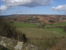 The path continues along the edge of the escarpment, until it reaches the road from Farndale. In front of you, you will see Gillamoor Church. Head towards the church. Just before you reach the church, there is a gap in the trees to your left, and through that gap, the famous 'surprise view'.
After you've admired the view (there is a conveniently placed bench), follow the road past the church and through the village. Turn left just after the pub.
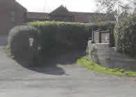 The road through the nature reserve brings you past a council depot, and then meets the Gillamoor road, just north of Kirkbymoorside town centre (turn left here if you want to visit the town centre). Here the correct route deveates slightly from the path marked on the Ordnance Survey map. Cross over the road and look for a cycle path to your right (see picture, right).
Follow the
path for just about 100 feet, then take the first available turn left (at a bench). Keep straight ahead on this new path until you have passed a large building (to your right).
The road through the nature reserve brings you past a council depot, and then meets the Gillamoor road, just north of Kirkbymoorside town centre (turn left here if you want to visit the town centre). Here the correct route deveates slightly from the path marked on the Ordnance Survey map. Cross over the road and look for a cycle path to your right (see picture, right).
Follow the
path for just about 100 feet, then take the first available turn left (at a bench). Keep straight ahead on this new path until you have passed a large building (to your right).
You will join a road running through some new houses. Turn right onto this road, which quickly turns to the left and heads west across the side of the hill, with good views away to the south. At the far end of the road, keep right into a corner (the Ordnance Survey map is now correct again). A footpath leads between two houses back into open fields.
Follow the path straight across the first three fields, then along the field edge for the next three. Enter a larger field with a wood to the right. Here, aim for the far left corne then follow the field edge west across two more fields.
At the road, turn left. Keep straight ahead at the crossroads (first encounted right at the start of the walk). 900 yards past the crossroads you reach the A170. Cross over carefully, and turn left to return to the start point.
Like most walks in this part of the moors, the clay soil means that the paths here can be slippy after rain. Proper walking boots and decent poles are recommended.
Once the bridges are fixed, take the path along the west side of Kirkdale past the church;