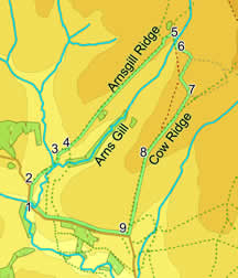
 This walk is in one of the quietest, most isolated parts of the moors, and yet is only just over four miles from Osmotherley, one of the bigger of the moorland villages! The walk starts in the upper reachs of Rye Dale, before taking us to Head House at the very end of Arnsgill Valley, and back along Cow Ridge, with stunning views back into Rye Dale, including an unusual view of Hawnby Hill.
Ascent: 915 feet/ 250 meters
Length: 5.7 miles/ 9.2 km
Map: OS Explorer Map OL 26
Go to printable version
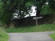
To reach the start point, drive south out of Osmotherley, before taking the first left turn, (signposted Hawnby). This road climbs up onto the edge of the moors, before turning sharply left and heading gently down into upper Rye Dale. After about a mile and a half of this, the road begins to drop more sharply, passing through Low Cote Farm before reaching a bridge over the Rye. Just before that bridge you will find a small car park (on the right).
 As the track begins to level out, another track leaves it to the right, heading up towards Hill End Farm (signposted as a footpath). Take this turn and keep climbing up the track.
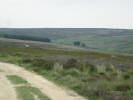 Continue on the track down to Arns Gill. Cross over the Gill, and follow the track as it starts to climb onto Cow Ridge. There is a footpath marked on OS maps leaving the track and heading directly towards the ridge, but it has disappeared under the heather. Instead, keep to the track as it climbs up onto the ridge (if the gate on the track is locked head along the wall to find the footpath gate). Two hundred meters after passing through the last stone wall, the track turns sharply right. Take this turn. Ignore another track that turns off to your left, and head south along Cow Ridge, before following the track as it climbs up the highest point on our walk.
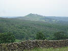
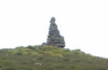 Not a navigation point, but a viewpoint. As you continue down Cow Ridge, you will spot a very tall, thin cairn on the skyline, and begin to suspect that it might mark a rather spectacular viewpoint. You'd be right. Just beyond the cairn, the ridge steepens, so from here you get an uninterupted view of upper Ryedale, down as far as Hawnby Hill. This is one of those moorland views that is simply too vast to photograph sucessfully, so you are going to have to walk here yourself to truly appreciate it.
 This walk is on Ordnance Survey Explorer Map OL26 (North Yorks Moors Western Area)
Get it from ![]()