Two valleys carry the Wheeldale name, running on the northern and eastern sides of Wheeldale Moor. To the north is the valley of Wheeldale Gill, which flows east though a forest in its upper reaches. To the east is the 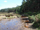 valley of Wheeldale Beck, which flows north-east across open moors, then forms the border of a forest, before running north to merge with the gill. The combined streams then form West Beck, which drops over Nelly Ayre Foss on its way to Goathland,
The dale is most famous for the Wheeldale Roman Road, an exposed stretch of roadway that cuts across the eastern flank of Wheeldale Moor, on the slopes west of Wheeldale Beck. This runs from the minor road that runs across the moors towards the Esk north/ north-east towards the valley.
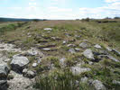 According to local legend the road was built by the giant Wade and his wife Bel, also credited with Mulgrave and Pickering Castles. It probably linked the Roman military outposts on the coast with the Cawthorne Roman Camp and the flatter ground further south.
Road access to the valley is provided by two minor roads. The first runs from Pickering to Newton-on-Rawcliffe, then turns north to drop down the northern face of the Tabular Hills. After that is passes through Cropton Forest to cross Wheeldale Moor. There is parking on the roadside at the western end of the Roman Road. The second starts in Goathland - take the road west out of the village. Just before it drops down to cross West Beck turn left onto a side road that runs down to a parking area at Gill View.
We have a walk that visits the Wheeldale Roman Road