|
|
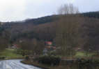 Wass is nestled in a valley that cuts into the southern escarpment of the moors. Wass is dominated by steep, wooded slopes on three sides, and even to the south there is a little more rough ground before the flat ground begins in earnest.
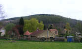 Grid Reference: SE 554 793. Just under two miles west of Ampleforth.
Shop, Church
Wombwell Arms pub (also provides accommodation)
Byland Abbey is close by (with car park).
 Wass is on Ordnance Survey Explorer Map OL26 (North Yorks Moors Western Area)
Get it from ![]()