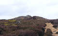
 Shunner Howe is a well preserved Bronze Age round barrow that later served as a lookout point and then as a parish boundary.
The barrow is 25m in diameter and 2.5m high, making it one of the larger barrows in the area. A 4m wide ditch survives to the south and east, with a 3m wide bank outside it. It probably dates to the Earl Bronze Age, and is of mixed earth and stone construction.
 The barrow was probably excavated in the 1850s, and this is probably the reason there is a hollow in the centre of the barrow.
The barrow remained important long after it was built. Its name means 'look out hill' in Old Norse, and it does offer good views in every direction apart from west, where the ground continues to rise for some time.
The barrow sits on a trail that runs west-east across the high moors, and was one at the junction of four parishes. It still lies on an administrative boundary and there is a boundary stone on the summit.
Grid Reference: SE 727 996
Walk SE 7295/01 Rosedale and Hartoft visits Shunner Howe