|
|
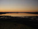 Scaling Reservoir is the largest lake in the national park, and one of the most unusual reservoirs you are likely to see. Where most dams are built at a narrow point, creating a long narrow lake that runs back into the hills, here the dam is built on the longest side of the lake, creating a short, wide lake. Even at its highest point the dam is comparatively low.
The dam is relatively high in the Moors, at close to 200 meters above sea level. To the south the Moors rise gently to a high point on Beacon Hill (299 meters), overlooking the upper Esk valley. Paths lead around the lake and up onto the Moors.
The lake was completed in 1958, and was quickly populated by wildlife. The south west corner was turned into a nature reserve in 1972. The rest of the lake is used for fishing and boating, with a club house at the western end of the lake.
There are car parks at each end of the lake.
Scaling Dam Sailing Club gives information about sailing on the lake.
Northumbrian Water provides fishing information (pdf, 2009)
 Scaling Reservoir is on Ordnance Survey Explorer Map OL27 (North Yorks Moors Eastern Area)
Get it from ![]()