 The River Seven is the river of Rosedale, flowing along the full length of the valley, from the wild north-western end of the dale near Rosedale Head, past the village of Rosedale Abbey and out
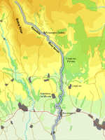
  through a narrow gap in the hills. The river changes in character several times. It rises in one of the wildest of the dale heads, flows through a former industrial valley, overlooked by some impressive ruins from the mining industry. At this stage the river runs through a narrow area of gentle fields, before becoming wilder once again at the mouth of Rosedale, where it flows past the western edge of the large Forest of Croptons. Finally the river calms down and meanders through one last valley before leaving the Moors at Sinnington.
The Seven isn't well served by footpaths. There is a stretch that runs north from Rosedale Abbey to Thorgill Farm, and a lovely area of paths north of Sinnington, but otherwise there are only short sections of path, mostly crossing the river.
The River Seven rises just below Rosedale Head and flows under the old railway line to enter Rosedale.
The Seven flows south-east through Rosedale. It then turns south and flows through a narrow wooded valley past the juncton with Harttoft. The river then meanders its way through some gentle hills to Sinnington where it exists the National Park and like many of the western rivers flows south into the Rye.
Cross Gill
Reeking Gill
Gill Beck
Cold Beck
Thor Gill
Gill Beck
Northdale Beck
Hartoft Beck
Lastingham Beck
Cropton Beck