 Lockton is an attractive village hidden just off the main A 169 road from Pickering to Whitby.
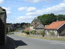
 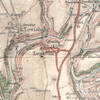 It runs parallel to the steep sided valley of Levisham Beck, which seperates it from the nearby village of Levisham. Lockton is a rather curvey village - the main road winds its way through the village while passing gently rising and falling as it goes (see picture, left).
The village was mentioned in Domesday Boom as Loca's Farm. St. Giles Church was built in the 13th century, but has since been restored.
Lockton has a combined village shop and tea room and a Youth Hostel in the village.
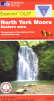 Lockton is on Ordnance Survey Explorer Map OL27 (North Yorks Moors Eastern Area)
Get it from ![]()