|
|
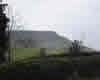 Tiny moorland village on the line of the Esk Valley railway. The Cleveland Way dips down into Kildale on its way across the head of the Esk Valley. Kildale is well placed for walks on the high moors to the south, north towards Roseberry Topping and east into the head of the Esk Valley.
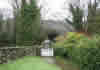 The railway station is found a little way outside the village. St Cuthbert's Church is reached by a charming bridge over the railway line.
If you follow the Cleveland Way north for two miles, you will reach Captain Cook's Memorial on Easby Moor, with superb views over Great Ayton.
The Kildale area has been inhabited for many centuries. A Viking hoard, including rare weapons, was discovered during renovations of St Cuthbert's in 1865. A motte marked on the map is probably entirely natural, and almost certainly not a Percy family castle.
Shop, Post Office, Public Toilets (at station), Railway Station.
References
AA Leisure Guide to North York Moors, pages 29-30
 Kildale is on Ordnance Survey Explorer Map OL26 (North Yorks Moors Western Area)
Get it from ![]()