|
|

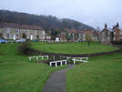
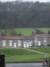 One of the most scenic villages in the moors, the houses of Hutton-le-Hole are arranged around the wide village green, with Hutton Beck running through the middle. Local sheep graze the green, keeping it neat.
Hutton-le-Hole is located in a triangular hollow in the moors. This "Hole" is a quirk of the local geology. The approach to Hutton-le-Hole from the south runs along the narrow valley of Hutton Beck, cutting through the Tabular Hills that make up the southern part of the moors. Hutton-le-Hole is located where the valley of the beck begins to widen out at the northern edge of the moors. Hutton Ridge 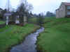 rises immediately north of the village, completing the triangle. The road north from Hutton-le-Hole rises for seven miles along Blakey Ridge, given fantastic views into Farndale and Rosedale and crossing some of the highest land in the national park, peaking at nearly 1,400 feet close to Old Ralph Cross.
 The road north out of Hutton-le-Hole is also one of the two routes into Farndale from the south - the first left turn outside the village leads to west Farndale, the second turn to east Farndale. The road east to Lastingham runs along the base of the northern edge of the Tabular Hills, here a wooded bank.
Hutton-le-Hole is one of the more touristy villages on the moors. It is the home of the Ryedale Folk Museum, and some interesting shops (including a particularly impressive chocolate shop).
The village contains plenty of shops of all types. Public Toilets and a large car park can be found at the northern end of the village.
 Hutton-le-Hole is on Ordnance Survey Explorer Map OL26 (North Yorks Moors Western Area)
Get it from ![]()