The isolated valley of Hartoft has a very different feel to most other dales in the North York Moors. Most of the area's valleys resemble the flat bottomed, steep sided dales of the central moors (of which nearby Rosedale is a 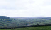 good example). In contrast Hartoft has gentle slopes with the steepest sections close to the beck. This sort of valley is not uncommon on the moors, but most are either heather-clad or shrouded in timber. In contrast Hartoft is a pastoral valley, split into slices by stone walls.
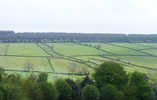 Hartoft's common moor was enclosed by act of parliament in 1769. It was split into the long narrow straight sided fields of equal width that still survive in much of the valley, and the fields distributed amongst the farmers who had previously had rights to graze on the common. The area above the enclosure fields is now dominated by forestry, especially to the east where Cropton Forest reaches to the edge of the valley.
 The valley probably never contained many more houses than at present – it had a population of 168 in 1848, and the 1914 ordnance survey shows roughly the same twenty houses at today. The valley did once support both a Primitive Methodist chapel and a public elementary school (established in 1876), both of which have now closed. The name is probably most familiar to visitors because of the pub at Hartoft End, on the main road into Rosedale.
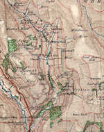
Grid Reference: The valley runs roughly from SE 748 924 to SE 742 976