|
|
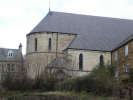
 Egton Bridge is a most unusual village, separated into two parts by the River Esk. The majority of the village is on the north bank of the river, and is dominated by the church of St. Hedda at one end and an ex-mill at the other. St Hedda's is a catholic church, built in the birthplace of Nicholas Postgate, the martyr of the moors.
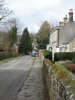
 One of the most intriguing elements of Egton Bridge is that the quickest route between the halves of the village separated by the River Esk is across two sets of stepping stones. Most of the houses are on the north bank, and the pub on the south bank. The bridge itself is seven hundred feet further downstream!
The current bridge was completed in 1993 to replace a 'temporary' bridge built after a flood in 1930 which washed away an earlier bridge of 1758.
 Grid Reference: NZ 805 053
Five miles west of Whitby, off the A171
Pub and restaurant on the southern side of the river.
Car park near the church.
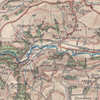
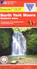 Egton Bridge is on Ordnance Survey Explorer Map OL27 (North York Moors Eastern Area)
Get it from ![]()