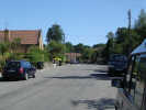
 Another attractive village on the northern edge of the tabular hills. Cropton is nicely placed for walking - to the north you have easy access to both open heather moor and the more recent forestry, while the valley of the River Seven runs west of the village.
 The church is well worth visiting for the tapestries, created in the village, which contrast well with the simple whitewashed walls.
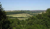
The impressive views from Cropton Bank look out towards Lastingham and beyond to Spaunton Moor.
The Motte and Bailey marked on the map are indeed the remains of a castle, recorded as in use in 1276 and again in 1334 but otherwise obscure.Grid Reference: SE 756 889
3.5 miles north west of Pickering, best accessed through Wrelton.
The Cropton Gallery sells paintings of the area and cards, with all the proceeds going to the local air ambulance
Follow the road north through the village to find Cawthorne Roman Camp. There is a car park and a good quality path runs around the edge of the camp, with some supurb views out over the high moors. The Roman earthworks have survived to a surprising height
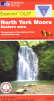 Cropton is on Ordnance Survey Explorer Map OL27 (North Yorks Moors Eastern Area)
Get it from ![]()