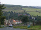
 Two things immediately attract attention in Commondale – first that the village is built on two steep hills, with the houses arranged along the road down the Esk at the point where it drops down to cross Commondale Beck and second that many of the buildings are constructed of brick. Until the 1950s the village contained its own brickworks. The village is almost entirely surrounded by higher ground – even the upper Esk is rather hidden by a bend in the valley, and the only gap is where the valley opens out towards Castleton.
Commondale used to be at the centre of a web of major routes, including the Monk’s Causeway from Whitby Abbey to Guisborough Priory and the main road down the Esk valley to the coast. The road that leaves the village to the east follows the line of this road, before coming to a sudden end at the T-junction at White Cross. The original road now continues across the moors as a track, before joining the main road west of Scaling Reservoir. The White Cross itself was once an important waymarker on the road, indicating the right place to cross the skyline on the way west to Commondale.
Our walk NZ 6510/01 Commondale starts just west of the village
Grid Reference: NZ 662 104