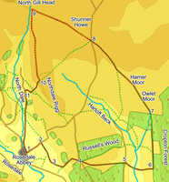
 This longer walk visits two dales and some of the highest ground in the area, starting in Rosedale and crossing the isolated valley of Hartoft before climbing gently up onto the high moors at the head of Rosedale.
The only flaw with this walk is that it requires both Explorer Maps of the Moors, starting on the western sheet, before swapping to the eastern sheet.
Ascent: 1,360ft
Length: 10 miles
Map: Ordnance Survey Explorer Map OL27 and Ordnance Survey Explorer Map OL26
Go to printable version
We start from the free public car park on the road that leads east out of Rosedale Abbey (just behind a hotel).
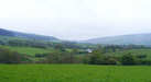 After just under a third of a mile a footpath crosses the road. Turn right onto this footpath, and follow it straight across a square field, heading for a stile in the far side. This brings us into an odd shaped field that no longer entirely matches the OS map, having been split in half lengthways by a fence and ditch. Head for a small footbridge that crosses both obstacles, then diagonally across the second half of the field towards a footpath sign. Cross into the next field, then turn right and follow the hedge line as it runs towards the left hand side of a farm (The Grange). The path passes to the left of the main farm buildings, then to the right of a large new barn. Once past this grange we follow a track that runs along the right hand side of the next two fields.
Soon after passing The Grange the line of the field wall begins to curve away to the left. We continue along the left hand side of the wall until we reach a tall ladder stile. Cross this stile and then continue in the same direction, but on the right side of the wall, all the way into the eastern corner of this field, where another stile takes is into the next field.
 Turn left and head uphill through this field, aiming to the right of a dip in the upper part of the field. Above this field a clear path leads up through a field of bracken, bringing us to the edge of the heather, where the path swings away to the right, before turning back left to reach Hancow Road close to a cattle grid.
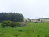
 Our route takes us down Hartoft Rigg, a patch of open heather moorland between two forests. To reach the start of this path cross the cattle grid. Ignore the first signposted footpath, which runs along the southern side of Russell's Wood. Just past this short stretch of unusually thick tarmac marks the beginning of a track across the moor. Just beyond this a footpath is marked leading through a wooden gate in a barbed wire fence. Follow this footpath, which runs through the open heather all the way down Hartoft Rigg, past a small patch of woodland, and onto the road along Hartoft.
 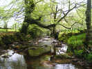 Our path has brought us out close to a T-junction. Turn left onto the road and then right at the junction (signposted as a right of way), and follow this side road as it drops down quite steeply towards Hartoft Beck. After crossing the beck the road curves around the main buildings of Birch Farm, where we join a lane that climbs up a narrow gap between stone walls up to the edge of the forest above the valley.
 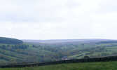 Turn left onto the path that runs along the edge of the woods. At the time of writing some fairly dramatic forestry works were being carried out, so the exact layout of the woods may have changed, but in May 2009 we followed this path along the edge of the woods for just over two thirds of a mile. The path then ended a wider band of trees, before emerging into an area of recently felled timber, where it continued on in the same direction until reaching a forestry track.
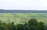
 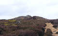 We reach the road at a small lay by close to some abandoned workings. One remaining sign of these workings are some grassy areas surrounded by grass. Cross the road, and head to the right of the lay by. This brings us to the largest of these grassy areas. Head diagonally across the grass to the north-western corner, where you will find a path heading up towards some mounds left behind by the workings. Follow this path, which sometimes resembles a track and sometimes a stream bed, as it climbs up to Shunner Howe, with fantastic views in every direction. From the howe follow the path as it continues to run across the moors, following an old boundary still marked with white stones.
 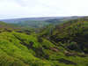 We remain on this path for just under two thirds of a mile, until it begins to drop down into the valley of North Gill. At this point look out for a slightly overgrown track that leaves to the left. Turn onto this path and follow it as it runs south along Northdale Rigg, with Northdale itself to the right.