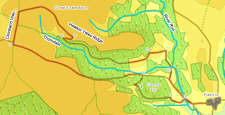
 This walk takes us west from the village of Hawnby into the hidden valley of Thorodale, onto the western escarpment of the moors and back across the edge of Great Arden Moor. On a good day the views to the west are very impressive, looking out towards the Pennines while the views into Thorodale are interesting on all but the foggiest of days.
Ascent: 1,550ft/ 475m
Length: 8.8 miles/ 14km
Map: Explorer 026 North York Moors West
Last Walked: 15 October 2005
Go to printable version
There is a limited amount of roadside parking in Hawnby. Take care not to block any gates or impede access.
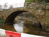 Follow the road as it crosses over the River Rye, and then turn left onto a footpath. This path runs parallel to the river for a very short distance, and then curves around to the right and begins to climb up the slope. The path passes through two fields, becoming a rough track in the second field. At the very start of a third field, turn right and climb straight up the side of Coomb Hill.
 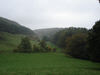 Where the track leaves the trees, the OS map shows the path zigzagging across the next field. There is now a permissive path that cuts off this corner. Head north west across this patch of open ground towards the corner of the field. At the northern edge of the open ground a track heads back into the trees, heading away to the right. Follow this until you reach a minor road.
 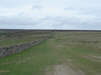 Turn right onto the Cleveland Way, and follow it north as it runs close to the top of the escarpment. Ignore the first right turn, about a third of a mile along the path, where a stone wall climbs up from the left, and continue on until you have walked about half a mile along the Cleveland Way.
 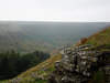 This track passes around the northern end of Thorodale and a side valley. After passing the top of the second of these valleys, the OS map shows a footpath that keeps close to the edge of the moors, but this was not visible on my last visit, so stick to the track. Where the track splits into two, take the right hand branch, and follow it as it curves sharply around to the right and descends into Thorodale.
 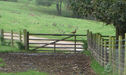 Where the track reaches the edge of the woods in Thorodale, turn sharply left onto the track that heads east into the woods. Follow this track as it winds its way down Thorodale, ignoring any single tracks joining from the side. At one point we reach a crossroads where two forest tracks cross - continue straight across here. The track eventually emerges from the trees just to the north of Arden Hall. Continue due east towards Mount Pleasant Farm. One field before reaching the farm our track joins another one climbing up out of the valley - turn left onto this track (seen here with a pheasant on the gate).
 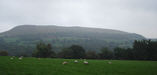 At Mount Pleasant turn right onto the track that heads due east through the farm. Continue along this track for just over one fifth of a mile.