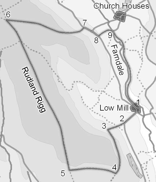
This walk takes us onto the southern end of Rudland Rigg, and offers fantastic views into Farndale and south towards the Tabular Hills. After a steep pull at the start, most of the walk is quite gentle as it follows the top of the rigg. We finish along the daffodil route in Farndale.
Ascent: 1000ft/ 315m
Length: 8 miles/ 13km
Map: Explorer 026 North York Moors West
Last Walked: 20 October 2007
We start from the car park in Low Mill.
This road heads directly towards a house, turning sharply to the just before reaching the building. At this point we leave the road and follow a footpath that continues on to the south west, passing just to the right of the house. This path passes through part of the house's garden and then a field, before reaching another small lane. We cross straight across this lane, into the next field. Here the path runs diagonally across the field, heading towards the far right corner. Here the path enters a small parcel of woodland, running through a clear gap in the trees.
We follow this track west for three quarters of a mile. Eventually it reaches a T-junction, where it meets the main track that runs along the top of Rudland Rigg. Turn right onto this track, which we will be following for nearly three miles.
This part of the walk provides us with a wide variety of views, down into Bransdale and Farnsdale, north towards the highest part of the Moors at Round Hill and Stony Ridge, and of course along the rigg itself, where old industrial works dominate. The best views are gained from the top of Golden Heights, about two miles along the track, just past the OS trig point.
Just beyond Golden Heights the top of Rudland Rigg narrows and drops down into a minor pass or saddle linking the valley of Ouse Gill to the left with that of West Gill to the right, before beginning to climb up again heading towards what would appear to be an unnamed summit, crowned by the remains of Cockam Cross. We stay on our track as it drops down into this saddle and as it climbs back out of the other side, ignoring a path and a track that cross our route at the lowest point on the ridge.
Just under half a mile after we cross this first track, we reach a crossroads, where another track cuts across our current route at a sharp angle. At this point we turn sharply to the right, and follow this track as it heads almost due east across the top of the moors leading towards Horn Ridge. Ignore any tracks that leave to the right and continue to run along this track as it runs towards the edge of the high ground.
At the edge of the high ground our track drops steeply down back into Farndale. Follow this track until it reaches a minor road, joining it at Monket House.
We are now going to return to Farndale along the famous daffodil walk. Cross the River Dove across a small footbridge. Two paths leave the far side of the bridge. Take the path that heads right across this field, heading towards Mill Lane and the buildings at High Mill. Turn right onto the lane and follow it as it runs through High Mill. At the end of the buildings follow the path as it passes through a gate onto the river-side path.
Follow this path all the way back to Low Mills. On a couple of occasions paths join this route - if in doubt follow the right hand branch, keeping close to the river. This is a delightful path, running through riverside meadows and woods.
Just before we reach Low Mills the river runs under the steep side of Goodwill Hill, visible through the trees on the opposite bank. This is the sign that we are almost back at our starting point. Just past this section, a footbridge crosses the river - take this bridge and follow the path as it climbs back up to the car park in Low Mills.