Printable version of war SE4597/03: Oak Dale
From a distance the western edge of the North York Moors looks like a single dramatic slope. Up close that turns out not to be the case. Small valleys cut into the side of the moors, and this walk follows one of them, Oak Dale, as it climbs up from Osmotherley to the top of the western escarpment.
Park in Osmotherley.
Ascent: 719 feet/ 219 m
Length: 4.24 miles/ 6.8 km
Map: OS Explorer Map OL 26
Last Walked: 16 February 2007
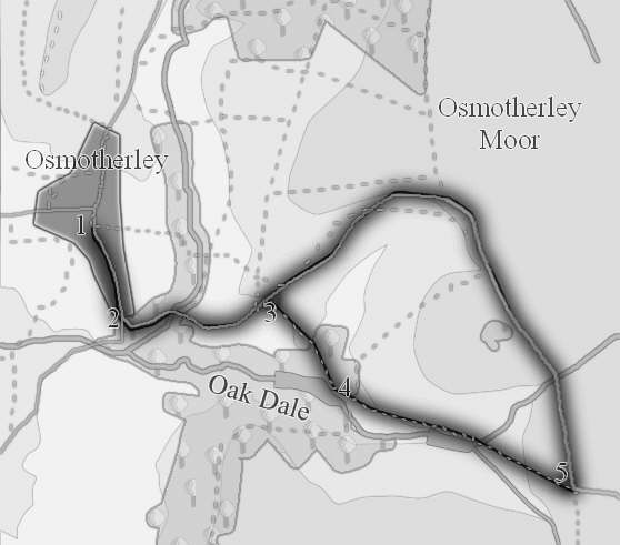
1: SE 456 972
From the centre of Osmotherley head south (down the hill). You will pass Osmotherley's famous public toilets. Follow the road to the edge of the village.
2: SE 457 967
Just at the edge of a village, turn left onto a lane signposted for Snilesworth and Hawnby. This lane dips down to cross over Cod Beck, and then begins to rise up Oak Dale. Continue on up this lane through the trees around Cod Beck and climb up between open fields.
3: SE 464 967
After around a third of a mile, turn right onto a track, signposted as a foot path. You are now on the Cleveland Way. This lane runs sideways across the hillside, before dropping down towards the lower Oak Dale reservoir.
4: SE 468 963
We are now in the valley bottom of Oak Dale. The path continues up the valley towards the upper Oak Dale reservoir. Above the reservoir it climbs steeply up towards the top of the escarpment.
5: SE 479 959
At the top of the slope you will rejoin the road from Osmotherley. Turn left onto this road, and follow it as it curves around the top of Oak Dale, before descending back into Osmotherley. If you want a longer walk turn right instead, and follow the Cleveland Way as it climbs up the side of Black Hambleton. Personally I consider the summit of Black Hambleton to have the best views in the moors. Return the way to came to rejoin this walk.