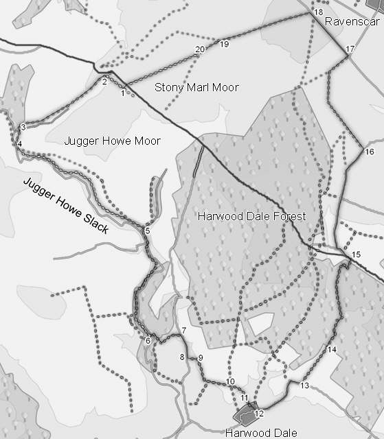
This walk takes us through four very different areas, representing some of the most typical features of the North York Moors. First is the valley of Jugger Howe Beck, a steep sided valley that winds its way between Jugger Howe Moor and High Moor. This valley leads us to Harwood Dale, through a mixed area of pastoral and arable farming. We then pass through Harwood Dale Forest, typical of the large areas of forestry to be found on the moors. Finally, we return to our starting point across the open moors above Ravenscar and Robin Hood's Bay, with some super views along the coast and west into the heart of the moors.
Ascent: 1000ft/ 325m
Length: 11 miles/ 18km
Map: Explorer 27
Last Walked: 16 September 2007
We start this walk from a car park off the A 171, just outside Harwood Dale Forest. This car park is actually the original route of the main road, since moved into a cutting, just to the north.
If you are approaching this parking place from the north, start looking out just after you pass the Flask Inn. Just as the road enters a cutting, look out for a right turn. From the south, start looking just after you leave Harwood Dale Forest. The road gently rises and swings to the left at the entrace to the cutting. Look out for a left turn.
At the bottom of the hill the path deviates rather from the right of way. The right of way crosses over to the west bank of Jugger Howe Back, turns south, then crosses back to the east bank. Not surprisingly, that no longer happens. When you reach Jugger Howe Beck, turn left and follow the path along the east bank of the beck.
After a short distance we reach the bridge over the beck (don't cross it). A clear track climbs up the side of the hill towards the top of Jugger Howe Moor. Take it, but after a very short distance leave it and follow the foot path that runs across the side of the moor.
When I last did this walk the path did not follow the route shown on the OS map. The right of way is shown cutting corners, climbing up and down the side of the hill and ending up on the top of the moor. At the time the in-places slightly swampy path stays in the valley bottom, taking advantage of the flat ground at the bottom of the valley (I did this walk after wet weather and it was perfectly walkable). Follow this path along the valley bottom as it runs roughly towards the east.
This has now changed, and the offical right of way has been restored, so it is possible to follow this path as it runs along the hillside and thus avoid the wet valley bottom.
Once again our path deviates from the right of way. At the southern end of the woods, the path is shown climbing up the steep side of the valley, before dropping back into the valley bottom. In fact the path follows the side of the beck all the way along the valley, until it reaches the track that comes down the side of the hill. Turn left onto this track and follow it down to a bridge over the beck. Once over the beck, turn right and follow the track as it climbs up out of the woods. At the top of hill, the track turns left, and joins a minor road.
Our path reaches a forest track at Teydale Farm. Turn right and then almost immediately left, on a path that soon reaches the main A 171. Cross this road (carefully!). On the far side of the road, turn onto the side road, signposted for Ravenscar. Ignore the signposted footpath - it runs through too narrow a space at the edge of the fields. Instead, stay on the road, then after 700 feet, turn right (still towards Ravenscar). We follow this road for just under a mile, as it climbs up onto the edge of Staintondale Moor.
A footpath is shown crossing a field and cutting a corner off our route, but this path doesn't appear to exist on the ground, so remain on the road until you reach a good quality farm track on the left of the road. Turn left onto this track.
This track runs straight for half a mile, then turns through 45 degrees to the right, runs this was for a short distance, then turns through another 45 degrees and runs back to the Ravenscar road close to a windmill. Follow the track through these turns.