SE8593/02: The Bridestones and the Hole of Horcum
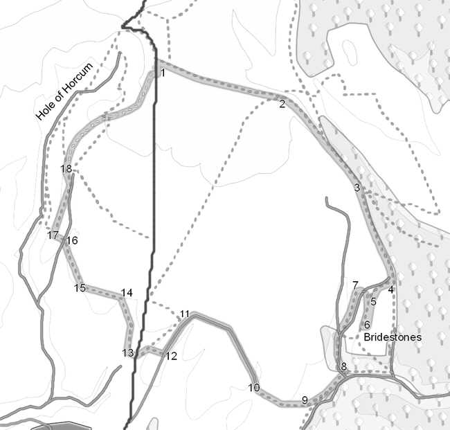
This walk takes in two of the most famous landmarks on the North York Moors - the Bridestones and the Hole of Horcum, while also provides great views east and west across the moors. Both of these landscape features were created by water erosion. In the case of the Hole of Horcum, we admire what has been taken away, at the Bridestones what remains.
Park in the car park at the Hole of Horcum. On a good day in the summer arrive early.
Ascent: 1,080 feet/ 330 m
Length: 8 miles/ 13 km
Map: OS Explorer Map OL 27
Last Walked: 3 February 2007
1: SE 852 936
From the car park head north (with the Hole of Horcum on your left), staying on the opposite side of the road to the hole. Just beyond the end of the car park turn right onto a lane that heads east. Follow this lane for just under a mile. Ahead are great views east across Dalby Forest and towards the coast.
2: SE 865 933
Leave the lane before it turns left to descend steeply down the side of Newgate Brow. Instead, stay on the high ground and take the path directly in front of you, along the top of the hill.
3: SE 873 925
When the path along the edge of the escarpment enters a forest leave it and turn right onto a path that runs alongside the trees. You have now entered the Bridestones Moor nature reserve, so the farmland on our right is now replaced by heather moorland. The path runs alongside a well preserved double bank and ditch.
4: SE 876 914
We remain on the path alongside the trees for two thirds of a mile, gently descending across the moor. We leave this path at the head of Bridestone Griff, eventually a steep-sided valley, but at this moment a flat grassy gap in the heather to the right of our current path. Ignore the first path, on the near side of the grassy valley, and take the path on the far (south) side of the grass, where the heather begins again.
5: SE 874 913
Follow this path as it rises gently to the left of the increasingly steep Bridestones Griff. Keep the trees in the griff to your right. This path eventually leads to a headland, where the valley turns left and blocks your route. Ignore the path that descends steeply down the slope and turn left onto the track that runs along the top of the moor. The Bridestones will be visible to your right. This track runs parallel to the Bridestones for some way, before joining the main path between the stones.
6: SE 873 910
You are now amongst the Low Bridestones. These are actually the more impressive stones, running in a line along the eastern side of Bridestones Griff. Go as far as the southernmost Bridestone, then turn back and follow the main path that runs between the stones.
7: SE 873 913
At the northern end of the Low Bridestones, this path dips across Bridestones Griff and climbs back up to the High Bridestones. These are more easily climbed, and even in early February were crowned with people eating their picnics. In case of severe weather you can shelter in a small cave that is eroding into the southern face of the last of this stones. From the High Bridestones follow the path left (south). You are now on the opposite side of Bridestones Griff, with good views across to the Low Bridestones. This path descends rapidly along Needle Point into the sheltered valley of Dove Dale.
8: SE 871 905
Dovedale runs into Staindale. Leave Dovedale across the foot bridge. Just outside the entrance to Dovedale you will find a track, Turn right onto that track, and cross a stream on stepping stones.
9: SE 867 902
This track runs along Staindale towards a farm. The public right of way is marked on the OS maps as going to the left of the farm, but the path on the ground goes to the right. On the far side of the farm, join the farm track that climbs steeply up out of Staindale. At the top of the slope continue on this track as it turns right then runs through a farm yard.
10: SE 862 904
One field beyond the farm the track becomes a proper tarmac road. Turn right onto this road and follow it as it curves gently left across the flat hillside.
11: SE 855 911
The road turns sharply to the left at Mount Pleasant Farm. Follow it past the farm, as there is currently no access through the farm to the right of way just beyond it.
12: SE 853 908
Continue along the road until you reach a stile that leads into the field on the right. Follow the path that follows the hedge as it leads down a slope between two abandoned quarries (this will be more obvious once you have reached the bottom of the slope). At the foot of the hill turn left along the base of the hill until you reach the main road.
13: SE 849 908
Carefully cross the main road, then follow the track almost directly opposite the stile. This track runs alongside a steep sided, flat bottomed but apparently dry valley (Jackdaw Griff). When the track reaches the base of the griff and doubles back to Warren Farm, leave it for the foot path directly in front of you. Ignore the main valley, and follow the foot path as it turns left up a side valley. There should be a footpath sign just visible on the brow of the hill. Keep on the left hand side of this minor valley.
14: SE 848 913
At the top of the hill you will reach a fence. The path crosses the fence and continues west alongside the left hand fence in the next field.
15: SE 845 914
Cross into the next field through the possibly rather muddy gateway. The path turns right by forty five degrees, and cuts across the corner of this field. Cross the next fence at a style, and continue on in the same direction. This second field contains a small copse of trees, which you need to keep to your right.
16: SE 843 918
The path now joins a track that runs down into Black Griff, another steep sided valley. Follow this track down to the right into the valley bottom, and stay on it as it climbs back up out of the valley on Far Black Rigg.
17: SE 842 920
Near the top of the slope there is a clear gap in the wall to the right. The path turns right through this gap, passing between a dyke that cuts across the Rigg. Continue along this field, aiming for the far left corner.
18: SE 843 926
At the end of this field, cross over a stile. You are now in an area of access land that runs around the rim of the Hole of Horcum. A clear path runs along side the fence around the top of the hole. Follow this path for a mile to reach the car park at the Hole of Horcum. About half way along a small spur sticks out into the hole, and provides some superb views down into the hole.